
Data Point related to: ELEMENT
Insadong-gil
Street famous for its traditional attractions, including galleries, souvenir shops, and restaurants, is accessible directly from Jongno (Jongno 3-ga). Insadong originally comprised two towns whose names ended in the syllables 'In' and 'Sa'. They were divided by a stream which ran along Insadong's current main street. Insadong began 500 years ago as an area of residence for government officials. During the early period of the Joseon Dynasty (1392–1897), the place belonged to Gwanin-bang and Gyeonpyeong-bang - bang was the name of an administrative unit during the time - of Hanseong (old name for the capital, Seoul). During the Japanese occupation, wealthy Korean residents were forced to move and sell their belongings, at which point the site became an area of antique trading. After the end of the Korean War, the area became a center of South Korea's artistic life and cafe culture. It was a popular destination among foreign visitors to South Korea during the 1960s, who called the area 'Mary's Alley'. It gained in popularity among international tourists during the 1988 Seoul Olympics. In 2000 the area was renovated, and, after protest, the rapid modernization of the area was halted for two years beginning that year. In recent years the backstreets of Insadong have continued to be gentrified with cafes, garden restaurants, and traditional pension-style accommodations. Insadong-gil is 'well known as a traditional street to both locals and foreigners' and represents the 'culture of the past and the present'. It contains a mixture of historical and modern atmosphere and is a 'unique area of Seoul that truly represents the cultural history of the nation.' The majority of the traditional buildings originally belonged to merchants and bureaucrats. Some larger residences, built for retired government officials during the Joseon period, can also be seen. Most of these older buildings are now used as restaurants or shops. Among the historically significant buildings located in the area are Unhyeongung mansion, Jogyesa, one of the most significant Korean Buddhist temples, and Seungdong Presbyterian Church, one of Korea's oldest Presbyterian churches. The central temple of Cheondoism can also be found in the vicinity, which was completed in 1921.
Type of Data Point - Basic Data Point - Source Wikipedia
Visit page of the element - Insadong-gil
Inserted: 12-01-2023 07:01:56
Questions related to this Data Point
 What are the most interesting historical buildings of Insa-dong neighborhood in Seoul?
What happened in the Insa-dong neighborhood of Seoul during Japanese occupation?
What is Insadong-gil street in Seoul famous for?
What is the history of Insadong-gil and Insa-dong neighborhood in Seoul?
Where can we find one of the oldest Presbyterian churches in Korea?
Contexts related to this Data Point
 Neighbourhoods in the city
 Streets in the city of Seoul
Walking area in the city
What to visit in the City
People related to this Data Point
No People found
Entities related to this Data Point
No Entities found


Dates/Years/Periods related to this Data Point
Image Gallery
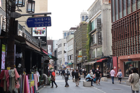
Credits: S h y numis, CC BY-SA 4.0, via Wikimedia Commons
Other Data Points

The National Archaeological Museum in Korçë, established in 1985, became broader and more complete after a reorganization in 1990. This museum is located in one characteristic house of Korça ...

Pyongyang TV Tower (평양텔레비죤탑) is a free-standing concrete TV tower with an observation deck and a panorama restaurant at a height of 150 metres (490 ft) in Pyongyang, North Korea. The ...

The last check-up on one of the most iconic buildings in Italy, the Tower of Pisa, has shown that the landmark is in excellent health. The article analyzes the last interventions and explore ...

The Petar Kružić Stairway, also known as the Trsat Stairway (Croatian: Stube Petra Kružića), is a stone stairway in Rijeka, Croatia, connecting Rijeka to Trsat. It starts from the archway at ...

Nestled beside the picturesque Vjosa River with a splendid view of Mount Nemërçkë, this relaxed hotel is conveniently located in the heart of Përmet town. The hotel provides comfortable and ...
Articles
View All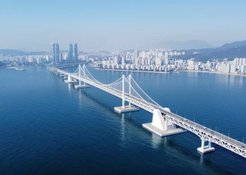
Gwangan Bridge - Busan - Glabb, CC BY-SA 3.0, via Wikimedia Commons
Infrastructures in South Korea
January 5th, 2024
Explore South Korea's vital infrastructures on our interactive map. From transportation to energy, delve into the nation's innovation and connectivity.
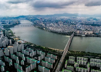
Tristan Surtel, CC BY-SA 4.0, via Wikimedia Commons
Along the Han River in Seoul
October 28th, 2023
The Han River, or 'Hangang' in Korean, symbolizes Seoul's history and daily life. Flowing through the city, it has witnessed millennia of events. From serene parks to lively light displays, it's a must-visit.
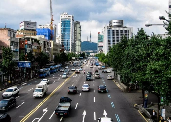
English: IGEL, CC BY-SA 3.0, via Wikimedia Commons
Streets in the city of Seoul
October 19th, 2023
Take a virtual stroll through Seoul's vibrant streets, exploring the historical arteries of Jongno and Myeong-dong Walking Street, as well as the modern pulse of Namdaemun-ro and Teheran-ro—all intricately mapped and curated for a personalized exploration of the city's diverse landscape.


